NAME
r.lfp - Calculates the longest flow paths from a flow direction raster map and a outlets vector map using the Memory-Efficient Longest Flow Path (MELFP) OpenMP parallel algorithm by Cho (2025).KEYWORDS
raster, hydrology, longest flow pathSYNOPSIS
Flags:
- -f
- Find full longest flow paths
- --overwrite
- Allow output files to overwrite existing files
- --help
- Print usage summary
- --verbose
- Verbose module output
- --quiet
- Quiet module output
- --ui
- Force launching GUI dialog
Parameters:
- direction=name [required]
- Name of input flow direction raster map
- format=string [required]
- Format of input flow direction raster map
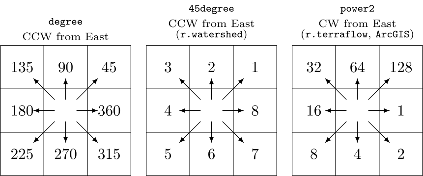
- Options: auto, degree, 45degree, power2, taudem, custom
- Default: auto
- auto: auto-detect direction format except taudem
- degree: degrees CCW from East
- 45degree: degrees CCW from East divided by 45 (e.g. r.watershed)
- power2: powers of 2 CW from East (e.g., r.terraflow, ArcGIS)
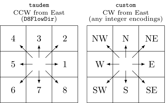
- taudem: 1-8 for E-SE CCW, not auto-detected (e.g., TauDEM D8FlowDir)
- custom: use encoding
- encoding=string
- Flow direction encoding for custom format
- Eight integers for E,SE,S,SW,W,NW,N,NE
- outlets=name [required]
- Name of input outlets vector map
- Or data source for direct OGR access
- layer=string
- Layer number or name
- Vector features can have category values in different layers. This number determines which layer to use. When used with direct OGR access this is the layer name.
- Default: 1
- column=name
- Name of input attribute column for outlet IDs
- Using a non-cat column is slower because of database access
- Default: cat
- lfp=name
- Name for output longest flow paths vector map
- heads=name
- Name for output longest flow path heads vector map
- coordinates=name
- Name for output longest flow path head coordinates file
- output_column=name
- Name for output attribute column for outlet IDs
Table of contents
DESCRIPTION
r.lfp calculates the longest flow paths for given outlet points using the Memory-Efficient Longest Flow Path (MELFP) OpenMP parallel algorithm by Cho (2025).NOTES
r.lfp can automatically recognize the following three different formats of flow directions: degree, 45degree, and power2. The degree format starts just above 0° at East (excluding 0° itself) and goes counterclockwise up to 360°, which also corresponds to East. The 45degree format divides the degree format by 45°. The power2 format starts from 1 at East and doubles clockwise up to Northeast.
r.lfp also supports the taudem format, which is used by TauDEM's D8FlowDir. This format is not auto-detected because it shares the same encoding range of the 45degree format. Additionally, the module can accept any integer encodings with the custom format and encoding option, which uses eight numbers for E, SE, S, SW, W, NW, N, and NE. For example, to encode the 45degree format using this method, one can use format=custom encoding=8,7,6,5,4,3,2,1.

Unless the -f option is specified, r.lfp defaults to computing the longest flow paths within each subwatershed, not crossing through any outlet points. This default behavior will produce longest flow path lines that do not overlap among subwatersheds. However, they can still overlap within a subwatershed if they are of the same length and share common downstream paths within that subwatershed.
With the -f option, the module first computes the longest flow paths at the subwatershed level, then performs a hierarchical analysis to derive potentially longer watershed-level flow paths, and finally eliminates shorter paths from both the subwatershed and hierarchically merged watershed results.
When parallel processing is enabled with the nprocs option, r.lfp uses OpenMP's shared-memory model and the specified number of threads to parallelize the computation per thread initially (implicit tasking through looping) and later switch to explicit tasking for better load balancing as threads start becoming ideal after they finish their allocated implicit tasks. This loop-then-task approach significantly improves computational efficiency along with highly reduced memory usage. In its benchmark experiment, the MELFP algorithm used in this module achieved a 66% reduction in computation time using 79% lower peak memory with 33% higher CPU utilization, enabling faster and larger data processing (Cho, 2025).
EXAMPLES
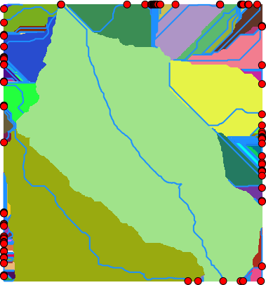
These examples use the North Carolina sample dataset.Extract all draining cells (all outlets for the elevation raster), and calculate all watersheds and longest flow paths:
# set computational region
g.region -ap rast=elevation

# calculate drainage directions using r.watershed
r.watershed -s elev=elevation drain=drain

# extract draining cells
r.mapcalc ex="dcells=if(\
        (isnull(drain[-1,-1])&&abs(drain)==3)||\
        (isnull(drain[-1,0])&&abs(drain)==2)||\
        (isnull(drain[-1,1])&&abs(drain)==1)||\
        (isnull(drain[0,-1])&&abs(drain)==4)||\
        (isnull(drain[0,1])&&abs(drain)==8)||\
        (isnull(drain[1,-1])&&abs(drain)==5)||\
        (isnull(drain[1,0])&&abs(drain)==6)||\
        (isnull(drain[1,1])&&abs(drain)==7),1,null())"
r.to.vect input=dcells type=point output=dcells

# delineate all watersheds using r.hydrobasin
r.hydrobasin dir=drain outlets=dcells output=wsheds nproc=$(nproc)

# calculate all longest flow paths
r.lfp dir=drain outlets=dcells lfp=lfp ocol=outlet_cat nproc=$(nproc)

# or using a custom format for r.watershed drainage (8-1 for E-NE CW)
r.lfp dir=drain format=custom encoding=8,7,6,5,4,3,2,1 outlets=dcells lfp=lfp2 ocol=outlet_cat nproc=$(nproc)

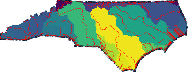
Perform the same analysis using the statewide DEM, elev_state_500m:
# set computational region
g.region -ap rast=elev_state_500m

# calculate drainage directions using r.watershed
r.watershed -s elev=elev_state_500m drain=nc_drain

# extract draining cells
r.mapcalc ex="nc_dcells=if(\
        (isnull(nc_drain[-1,-1])&&abs(nc_drain)==3)||\
        (isnull(nc_drain[-1,0])&&abs(nc_drain)==2)||\
        (isnull(nc_drain[-1,1])&&abs(nc_drain)==1)||\
        (isnull(nc_drain[0,-1])&&abs(nc_drain)==4)||\
        (isnull(nc_drain[0,1])&&abs(nc_drain)==8)||\
        (isnull(nc_drain[1,-1])&&abs(nc_drain)==5)||\
        (isnull(nc_drain[1,0])&&abs(nc_drain)==6)||\
        (isnull(nc_drain[1,1])&&abs(nc_drain)==7),1,null())"
r.to.vect input=nc_dcells type=point output=nc_dcells

# delineate all watersheds using r.hydrobasin
r.hydrobasin dir=nc_drain outlets=nc_dcells output=nc_wsheds nproc=$(nproc)

# calculate all longest flow paths
r.lfp dir=nc_drain outlets=nc_dcells lfp=nc_lfp ocol=outlet_cat nproc=$(nproc)

# or using a custom format for r.watershed drainage (8-1 for E-NE CW)
r.lfp dir=nc_drain format=custom encoding=8,7,6,5,4,3,2,1 outlets=nc_dcells lfp=nc_lfp2 ocol=outlet_cat nproc=$(nproc)

SEE ALSO
r.hydrobasin, r.flowaccumulation, r.accumulate, r.watershedREFERENCES
Huidae Cho, September 2025. Loop Then Task: Hybridizing OpenMP Parallelism to Improve Load Balancing and Memory Efficiency in Continental-Scale Longest Flow Path Computation. Environmental Modelling & Software 193, 106630. doi:10.1016/j.envsoft.2025.106630AUTHOR
Huidae Cho, New Mexico State UniversitySOURCE CODE
Available at: r.lfp source code (history)
Latest change: Sunday Nov 23 09:54:48 2025 in commit: 9cf49110ba3910c157a5685dc9648655512e7ded
Main index | Raster index | Topics index | Keywords index | Graphical index | Full index
© 2003-2025 GRASS Development Team, GRASS GIS 8.4.3dev Reference Manual