Note: A new GRASS GIS stable version has been released: GRASS GIS 7.6, available here.
Updated manual page: here
NAME
g.gui.tplot - Plots the values of temporal datasets.KEYWORDS
general, GUI, temporalSYNOPSIS
g.gui.tplot
g.gui.tplot --helpg.gui.tplot [stvds=name[,name,...]] [strds=name[,name,...]] [coordinates=east,north] [cats=string] [attr=string] [output=name] [size=string] [--overwrite] [--help] [--verbose] [--quiet] [--ui]
Flags:
- --overwrite
- Allow output files to overwrite existing files
- --help
- Print usage summary
- --verbose
- Verbose module output
- --quiet
- Quiet module output
- --ui
- Force launching GUI dialog
Parameters:
- stvds=name[,name,...]
- Name of the input space time vector datasets
- strds=name[,name,...]
- Name of the input space time raster datasets
- coordinates=east,north
- Coordinates
- cats=string
- Categories of vectores features
- To use only with stvds
- attr=string
- Name of attribute
- Name of attribute which represent data for plotting
- output=name
- Name for output file
- Add extension to specify format (.png, .pdf, .svg)
- size=string
- The size for output image
- It works only with output parameter
Table of contents
DESCRIPTION
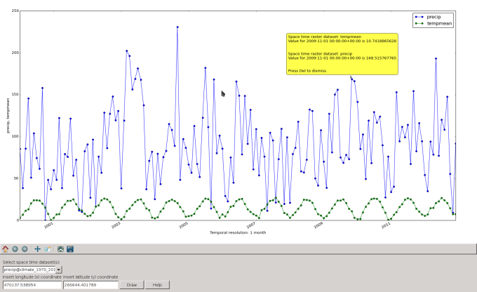
The Temporal Plot Tool is a wxGUI component which allows the user to see in a plot the values of one or more temporal datasets (strds, stvds, str3ds) for a queried point defined by a coordinate pair.Supported features:
- temporal datasets with interval/point and absolute/relative time,
- 2D plots,
- pop-up annotations with values information,
- automatic output to query several point.

NOTES
g.gui.tplot requires the Python plotting library Matplotlib.SEE ALSO
Temporal data processingwxGUI
wxGUI components
AUTHOR
Luca Delucchi, Fondazione Edmund Mach, Italy$Date: 2014-06-26 06:50:20 -0700 (Thu, 26 Jun 2014) $
SOURCE CODE
Available at: wxGUI Temporal Plot Tool source code (history)
Note: A new GRASS GIS stable version has been released: GRASS GIS 7.6, available here.
Updated manual page: here
Main index | GUI index | Topics index | Keywords index | Graphical index | Full index
© 2003-2019 GRASS Development Team, GRASS GIS 7.2.4svn Reference Manual